

jindydiver
-
Posts
1,536 -
Joined
-
Last visited
-
Days Won
1
Content Type
Profiles
Forums
Events
Shop
Posts posted by jindydiver
-
-
13 hours ago, Croan Choille said:
G'day
Did you buy from that site? I know someone who is just getting into hunting and these would be just the shot for him but I am not too keen on recommending random sale sites. I like my diamondbacks, I have been using them for well over a decade now and they are still doing what I bought them for?
-
 2
2
-
-
9 hours ago, Fussy said:
Cutting antler?
So I want to split some antlers to use as handles.
I understand it's basically tightly packed hair, so cut slowly?
Or split it like long grain timber?
Any suggestions greatly appreciated.
Antler is bone. To split it you use a bandsaw.
-
1
-
-
any saw blade over 18 inches in circumference will make decent knives, you just need to test your heat treating recipe to make sure you get it right. I have made hundreds using the same recipe as L6 and have had a bunch of them tested (they all came up between 59 and 61). The cold saw blades are shit, they are HSS and are near impossible to heat treat at home.
-
Love my icebreakers spencers, only hassle is if the moths or silverfish find them over summer and you get a few holes LOL
-
Hey that's the go, I tell you my experience with the rino, which happens to be different to your own and the next thing you know it must be user error rather than just an honest relation of their worth on that trip. The guys were on a rise easily 10km away and we had reasonable line of sight and could talk to them fine (bit scratchy but usable), but down in the timber and creek lines and they were just not as good as our unidens.
-
A couple of guys I regularly hunt Cape York with have these units and I was less than impressed with what they could do. There were many times where tree cover cut the signal from them so badly that my mate and I could talk to the rino guys, but they could not talk to us (my mate and I use Uniden units). We were waiting at one pick up point for ages calling them on the radios and getting no reply, we got impatient and took a drive down the track and found them walking out about 2km away. They told us they could hear us fine but were wondering why we couldn't seem to hear them. They liked the polling function on their units. If they got separated (happens a lot when you bowhunt creek lines ) the units would show where the other guy was.
We have enough trouble with our unidens up in the hills, I can't imagine I would ever buy a rino.
Get a decent garmin though, they have great features that are very handy for hunters.
-
Spoke to him last night, said he was gentle on cleaning it up and there wasn't any engravings/markings.
Will update him hopefully on Monday with the new info.
Yep, real Japanese swords have all the makers marks hidden by the handle, so you are still no further ahead at this point

-
It appears to have extra cord wrapped around the handle. If you pull this off you might find a more traditional handle finish below it. If you do you will see a pin that is used to hold the blade in place. If you push the pin out (it will be obvious which side is bigger) the handle can be removed, then you will be able to get a look at the makers marks on the blade (called the mei).
-
They are swags? they look a lot like hiking tents made out of canvas
-
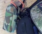
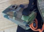
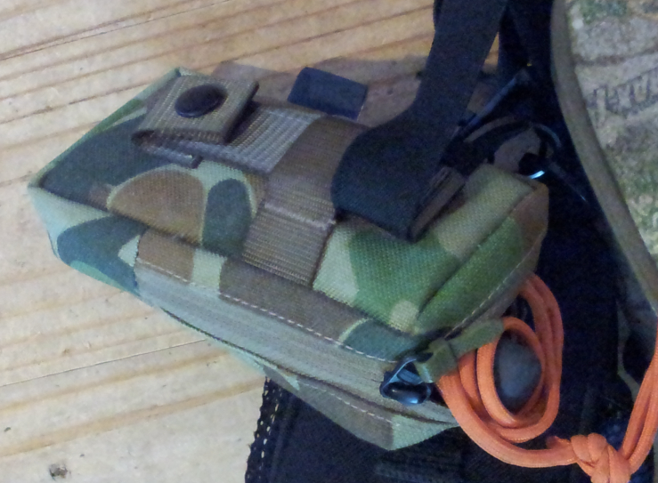
my pouch from placatac
-
I have a small lined gps pouch from Placatac on my bino harness strap. It means that even if I take my pack off for whatever reason I still have my gps with me. It is super handy hanging there against my ribs too.
-
Yes Dad LOL
Garmin, the best model he can afford (but ignoring paying for a camera).
I have the 62s and if I had to replace it today I would buy the Etrex 30. He could go one of the touchscreen models if he was keen on them, but I don't believe the softer touchscreen will stand up to abuse as well as the glass screen on the 62 units.
-
Exactly !! And I am saying just check your download has produced the same data as the physical map showing the exclusion zones supplied by the " Forestry service " to the Game Council. Download can get corrupted or the download link could take you to the wrong map and you don't notice it until you are in the field . The Forestry Service sets the exclusion zones . However you always have to disagree and then you back track .
You are alway arguing against common sense .
No, the problem is you are having trouble understanding the technology.
If you rely on downloaded waypoints to map out an exclusion zone you are taking one risk and that is what if a waypoint is wrong , what if many of them are wrong ? It is unlikely to happen but assembling grid references to establish a waypoint takes some precision and it is easy to make a mistake and exclusion zones do change .
When you are downloading the KMZ file from the GC you are not downloading "waypoints to map out an exclusion zone" , you are downloading a geo-referenced raster image. The download is an exact copy of the physical map (a scan) and the locations of exclusion zones will not be any different in your scanned copy.
I am also surprised you believe you could somehow download and install the wrong map and not have noticed it is the wrong one as soon as you open it in Google Earth so you can transfer it to your GPS.
-
I know that if you manually put in a waypoint and the change the datum it will ,in my old gps, change the location of the waypoint.
What model is your old GPS?
-
So if you are using a Kmz file that is made using wgs84 information in a gps that is set to adg66 for example and you may find yourself hunting in the wrong area accidentally.
KML and KMZ files are in one datum only called "WGS 84 Auto". When loaded into your Garmin mapping GPS they are transferred in that same datum ALWAYS, as are all waypoints and other data. The only effect changing your datum on your unit has is to change the location co-ordinates WRITTEN on your waypoint screen, it does not change the location of your cursor on your units map display.
This discussion has me wondering about your legend hcx though. If changing your datum while you are standing in the same spot moves your cursor then it is probably a good thing they are superseded. Did you test this?
-
Mick, lets just agree to disagree on this one.
I have a boat parked on its trailer, outside with Furuno GPS chartplotter, and chart chip. When i turn it on its hows the vessel location as in my yard. When I alter the datum on the plotter - the chart overlay shows the vessel a street away (up to 150 yards approx if you zoom in).
Admittedly marine charts aren't great for such measurements in suburbia - however this one has the navigable waters of the swan river nearbye so is quite accurate when zoomed right in.
There are not a great deal of changes between recent datums BUT some of the older ones AGD 84 for example to the new datums - can be up to 200 meters out in the position on ground.
Sorry, we just don't agree is all, - no need to get into a argument about it, lets just agree to disagree.
The question is about which one to buy after all - the thing about arguing with authorities - is another question entirely i.e a derail (albeit an interesting one) and perhaps the worthy subject of a new thread. No blood, no foul - play on. ;o)
Cheers!
I don't know how you can use your chartplotter as an example in our discussion (not an argument LOL ) when the OP is asking about GPS units (Garmin by default) compatible with the GC maps available on their website.
If setting the datum on a the Garmin mapping units changed the position of the cursor on the map displayed it would make the mapping display useless if you were also using a paper map of a different datum. You could just imagine the confusion if someone loaded the GC maps (originally in '94) and they were carrying the most recent map available from CMA (many are still '66), either the cursor would not be displaying their location correctly on the screen, or the data provided would have them marking there paper map in the wrong spot. It would be patently ridiculous for the Garmin mapping GPS units to work like that especially when the best practice is to have a paper map with you.
-
Just downloading the file from GC doesn't ensure its accurate in your GPS. You have to know what map (chart for marine) datum the game council overlay and map are produced in, and you have to have YOUR gps set to that same datum - otherwise as sated you can be anything up to a couple hundred meters out on the ground. You also can't assume that any ranger, policeman or GC official knows how to navigate, as far as getting his GPS settings right. Some of the younger tech savvy ones might while older guys unfamiliar with the technology might NOT be so well up on it. Depending on the authority - they might have their own individually owned GPS unit - and have it set right to the correct datum for that particular job and that map - while if its a larger authority where gear is kept in the safe and shared, the last guy who used it may have set it to a different datum for a different aged map, doing some forestry work etc, and the next guy never knew he had to alter the datum, when he downloaded the new maps for the current job.
You are confusing the issues here. It matters not one bit what datum your GPS is set to if you are relying on the maps loaded into your GPS from the GC. If that cursor is inside the forest boundary then you can have confidence that you are also, datum settings on your GPS do not change your position relative to the map displayed. What they do is change the reported position figures in the format you ask for and this only has any effect if you are using this written data to find your location on a paper map you may be using in conjunction with the GPS.
Walk outside with your GPS, take note of where the cursor is on your map screen, and change the datum to a different Aus datum and see for yourself. The cursor will not move one meter. Go all out, change it to Bermuda (with the Clark spheroid) and see it still does not move.
The whole GPS system works on ONE datum and all the maps you load are georeferenced in that same datum, as is the cursor on your screen. What setting the datum on your unit does is prime the converter/calculator so that the data displayed is written in the format you want to use with your paper maps. It is of course a good idea to have those paper maps and have your GPS datum set to match those maps, but this is a different issue to the calibration of the maps installed on your GPS unit (which is what we are talking about). Go back in the thread and see that Happy Jack posted....
I agree that a Garmin is a better unit.
If you rely on downloaded waypoints to map out an exclusion zone you are taking one risk and that is what if a waypoint is wrong , what if many of them are wrong ? It is unlikely to happen but assembling grid references to establish a waypoint takes some precision and it is easy to make a mistake and exclusion zones do change .
Before setting out you should check them against the latest GC maps to makes sure they look to be in the right places .
I am pointing out that the map Happy Jack is saying we should check our download against IS THE SAME MAP, and it is the only map you can rely on for exclusion zone info because it is the map the GC rely on to regulate those exclusion zones.
I.e. being a "qualified navigator" is not a prerequisite for a policeman or forester for example - most of them get pretty good at it, with experience...and because the technology is now a lot cheaper and more readily available a LOT of the younger guys fresh outta Uni etc will understand it who are exerts on GIS a lot better than some of the older guys (like me for eg) who did their studies back before the pocket calculator and digital watch were invented.
In my case it was only doing Master 5 at a mature age that got me qualified in navigation - non of my work in Forestry or Wild Life Officer roles covered chart (& map) datums on GPS for example.
Lastly if you've been around long enough (as I have), I have been out in the field (and at sea) on 2 occasions in the last 20 years where GPS failed me.
When I did my coxswains we did not have the benefit of GPS, you either got it right or you could get it very, very wrong.
But this isn't about what is appropriate for navigation at sea, or indeed for navigation that might be needed to save your life out hunting, it is about the OP wanting to buy the correct GPS so he can make good use of the available technology and have a hunt in a public forest without falling foul of the law.
-
Have you had a look at the KMZ data on the GC website? It is an overlay map made from the exact same map you are given with your written permission. For the KMZ to be wrong the written permission must also be wrong. You would be relying on exactly the same info the GC and the Police rely on when enforcing the exclusion zone on your written permission.
If you are told the detailed map you get with your written permission is the legal document you must refer to when deciding where to hunt and the custom map overlay of that same document provided by the GC is the same on your GPS as it is on the enforcement officers GPS you can expect that when you run into the guy deep in the guts of some tall timber you are going to be agreeing as one about where you stand legally. After all the two maps rely on the exact same data in their construction and you can see the GC download is as accurate as any map is as soon as you open it in Basecamp. You can also bet that if it wasn't accurate the GC would be told pretty quickly after they release it, people who use those maps are checking to see they are georeferenced correctly.
I know this as facts. In Hampton forest an incident showed us how this will work. A fellow has a block backing on to the forest and he doesn't have a back fence to his place (he wanted to feel like the whole forest was his back yard). A hunter wandered down stalking some goats and he shot one that ran on to the private block. The hunter ended up having words with the land owner (who is not a supporter of the GC) about whether the goat was shot on private land or in the forest. The police attended, as did the GC, and the same data you are provided with by the GC was used in both the GC and Police GPS units to determine the hunter (and the goat) were in the forest when the goat was shot.
When it comes to decide what info I want to use to keep myself within the law I will always go with the same info the enforcement officers are going to use to determine if I am within the law.
-
Ok so i will go with the garmin 60, and yes i will be downloading the latest map systems the GC offers before i go.
If you have the cash go the 62s
-
I agree that a Garmin is a better unit.
If you rely on downloaded waypoints to map out an exclusion zone you are taking one risk and that is what if a waypoint is wrong , what if many of them are wrong ? It is unlikely to happen but assembling grid references to establish a waypoint takes some precision and it is easy to make a mistake and exclusion zones do change .
Before setting out you should check them against the latest GC maps to makes sure they look to be in the right places .
There is no risk if you download the KMZ file from the Game Council site.
-
For programs on the PC like OziExplorer you have a separate file called a .map file that holds all the referencing (between 4 and 9) waypoints and the pixels on the picture where those waypoints are found and having a path to where the image file can be found. Your Garmin uses .kmz that is referenced in UTM or Lat/Long (depending on your firmware) and the kmz file contains the image and all the referencing info.
-
Is Geo tagging the same as Geo referencing ?
Nope
I don't geotag anything, it is a case of never needed to. It is when you say take a photo of something and you tag the photo with a waypoint. It is used by people who want to go back through their tracks and keep a log of the things they have seen. I know some US guys who use the camera in their GPS and they tag pics of scrapes and beds and whatnot so that they can add them to a map for friends. People who spray weeds will often use it too to mark weeds they see and produce maps that have lots of extra info in them so they can plan weed programs. You see examples of it on Google Earth when you click on a waypoint someone has posted and a pic comes up.
Goereferencing is where you have an image that is a map and you add a file to it that tells the GPS where the map is on Earth so you can use it. There are programs like OziExplorer that allow you to (within your PC) scan maps from anywhere and reference them using waypoints you create so that you can then reference the image to any other map of the same area. It is used to turn aerial images into maps for instance. Other programs can work in conjunction with this (like Mapc2mapc) and creat custom garmin images out of the pictures so they can be viewed on your GPS while you are in the field.
This allows hunters (and others of course) to use any map they can find to help them on the ground. Any time I am hunting in Vic I can access on my GPS the shonkymaps image or I can use the VicFire map of the same spot, or if I am worried about crossing in to a no-hunting area (like a park or scientific reserve) I can bring up the DSE map and check I am still in legal ground.
I have used this sort of tech for years (at a fairly basic level really) to create maps I can view on my PC from old aerial photos of the Snowy Mountains and I can create waypoints for interesting locations and visit them. I spent a lot of time diving on the old townships flooded by the Snowy Scheme and the only way to find the locations was to use a gps (all the locations being under many meters of water now. Nowadays I can load the maps directly on my GPS and plan on the run.
-
with the whole no pressure navigation situation it made the day far more enjoyable .
That is the beauty of them. They are super reliable these days and you just have a spare set of batteries in the bottom of your pack and you are pretty unlikely to not be able to use it to find a way home.
My GPS has saved me hours of hunting time over the last couple of years. If I whack a deer across a steep and bushy gully and I want to find it quicker I take a bearing to the animals with the electronic compass and project a waypoint (knowing the distance with my rangefinder) and just take whatever easier route I need to to get to the deer. I have used the same technique to find arrows shot up cliffs and whatnot.
-
Well if you can get all those maps into 1.3gb then I don't reckon ill ever need more than that.
It doesn't have all the maps available for all those editions, so far it is just the places I have hunted. As I go I keep adding more and more and in a couple of years I imagine I will easily have over 2gb installed. I leave them loaded, they don't slow down the unit at all and I don't want to fiddle every time I go hunting, I only want to adapt and load maps for new areas. All of them are available to view on the Garmin software and it is good to be able to learn as much about an area as I can before I visit it for the first time.
I would like a GPS for a couple of reasons:
An additional layer of safety in the remote outback,
The novelty (let's be honest, gadgets are cool)
And to createour own maps when we get back to town. The area we ho isn't particularly well mapped so this will help add detail to them
When I go to remote areas (the Cape and Aust Alps) it is great to be able to view sat images and make plans on the go. The ability to add custom maps is a big plus for the newer units. If you hunt in NSW the Six Images latest aerial pics are great and detailed enough in some areas to pick out bushes only as big as a couple of foot across.

Vortex rangefinder
in Binoculars, Spotting scopes and Rangefinders
Posted
Thanks guys